The route from Geiranger
Trollstigen lies at the northern end of the National Tourist Route Geiranger-Trollstigen. The route is about 104 km long in total, climbs to 1,038 m and includes a ferry crossing. From Geiranger you drive over Ørnevegen (Eagle Road) to Eidsdal, passing the Ørnesvingen viewpoint at the top of the road.
In Eidsdal you board the Eidsdal-Linge ferry; the crossing takes about 13 minutes. From Linge it is about 39 km to Trollstigen, a drive of about 42 minutes. The road runs through Valldal and past Gudbrandsjuvet up to the plateau. From there it descends through the hairpin bends into Isterdalen, a side valley of Romsdalen, and on towards Åndalsnes.
How to get to Geiranger is covered under Getting there.
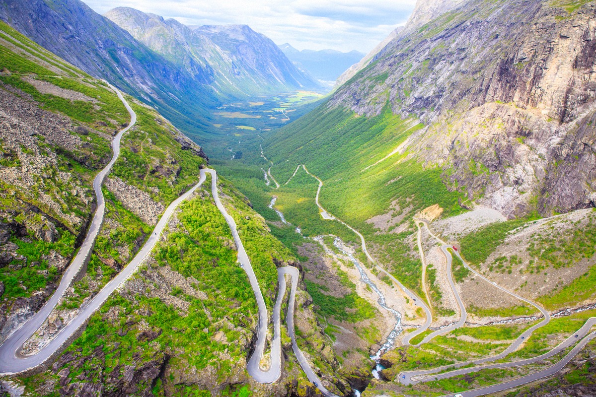
The eleven hairpin bends
The pass road winds up from Isterdalen to the plateau in eleven hairpin bends. It opened in 1936. Halfway up the gorge, a stone arch bridge crosses Stigfossen, a 180 m waterfall.
Buses up to 13.3 m long are allowed on Trollstigen.
On the plateau above the hairpin bends is a viewpoint designed by Reiulf Ramstad Arkitekter. The largest platform is 200 m above the road. The site is partly wheelchair accessible.
In 2022 an avalanche from the Bispen peak badly damaged the service building on the plateau. There is a kiosk and a shop on the plateau, and you will also find a café with a shop down in Isterdalen.
Gudbrandsjuvet and Valldal
Between Valldal and the plateau lies Gudbrandsjuvet, a gorge with potholes carved by the water. A structure by Jensen & Skodvin leads over the potholes of the Valldøla river.
The café at Gudbrandsjuvet is open daily in summer from 10:00 to 17:00, and the toilets from mid-May to mid-October.
Valldal lies on the road between the ferry and the pass. More places around the fjord are covered under Day trips.
Season and closures
Trollstigen is closed every winter. When the road closes and reopens varies from year to year. Even after it reopens, it can be closed at night or in bad weather.
If only the section with the hairpin bends is closed, the plateau can still be reached from Valldal.
Statens vegvesen reports current closures in its traffic information. Route information is published by Nasjonale turistveger (National Tourist Routes). What the weather is like on the fjord is covered under Weather.
Without your own car
Guided tours to Trollstigen start in Ålesund or Åndalsnes, for example. The tour listings at the top of this page show where each one starts.
More tours around the fjord are listed under Tours.